People from around the world can now explore Bangladesh from their smartphone or PC with the launch of Google Street View service in the South Asian country on February 5, 2015. Roam the streets of Dhaka and Chittagong, Bangladesh's two largest cities, or explore digital panoramic imagery of 40 of the country’s most important historic, heritage, and tourism sites, also available on Google Maps.
Bangladesh's Street View was a year in the making — on February 14, 2013, the Google Street View car started its work from Uttara in Dhaka. The country becomes the 65th to have this Google service, first launched in May 2007.
Street View in Bangladesh is the result of collaboration between Google and the Access to Information (A2I) Programme at the prime minister's office in Bangladesh, which is supported by the United Nations Development Programme and the US Agency for International Development.

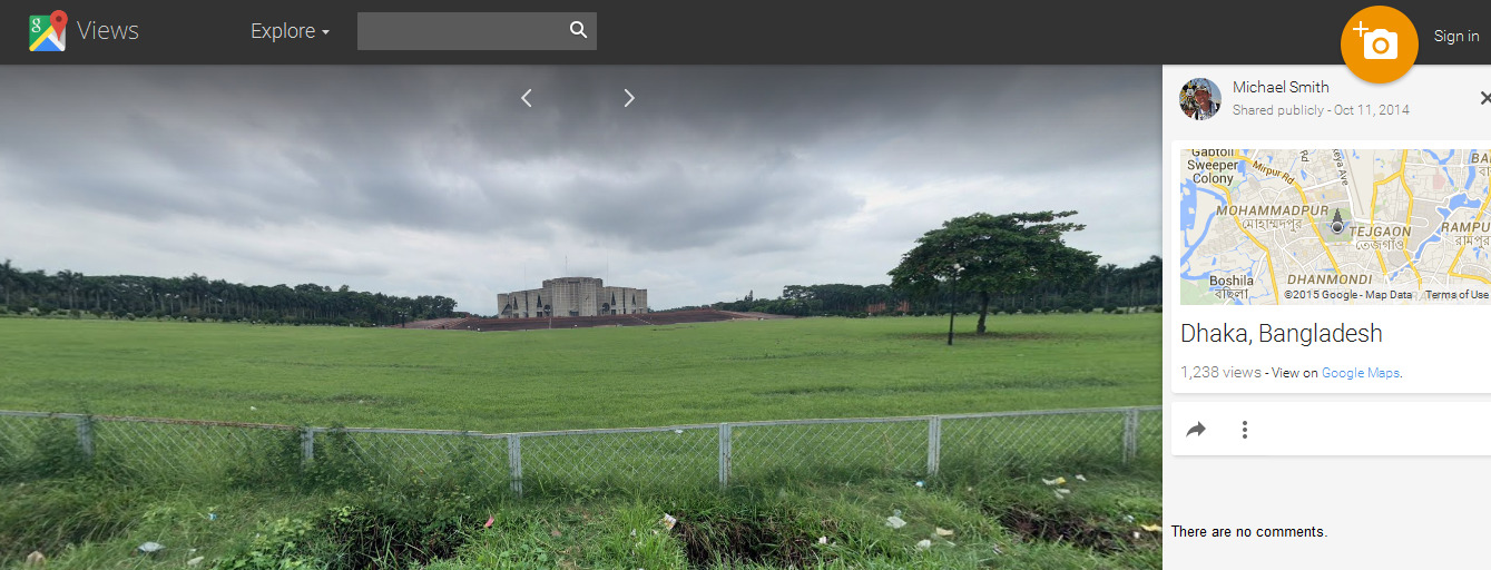
Bangladesh Parliament House in Google Streetview
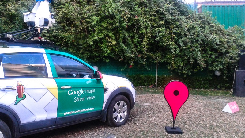
Google Street View is a technology featured in Google Maps that displays panoramas of stitched images of streets in a high-quality 360-degree view. Most photography is done by the Google Street View car, but some is done by trekker, tricycle and underwater apparatus. The Street View car has nine cameras, GPS and laser technologies which record the distances between the camera and landmarks. The recorded images are then processed and personal info (faces, number plates, etc.) is blurred, and then the images are added to Google Maps.
#StreetView car stops play. Welcome to the team, #Bangladesh! http://t.co/sn2wp4Gu9G pic.twitter.com/e2k3AWIylv
— Google (@google) February 5, 2015
Many Bangladeshis shared their reactions to the launch on social media. Pavel Sarwar, CEO of a software startup in Bangladesh, posted a humorous photo on Facebook with the caption:
#GoogleStreetView এ নিজের লুঙ্গি দেখে খুবই মজা পাইলাম।।
Kajal Abdullah wrote on Facebook:Amused to see my lungi [a sarong-like cloth] in #GoogleStreetView
কয় ঘন্টা ধইরা ঢাকার রাস্তার স্ট্রিটভিউ দেখতেছিলাম! বাসার সামনের রাস্তা দিয়া হাইটা আসলাম। মোবাইলে গুগলের স্ট্রিটভিউ দিয়া! মাথা নষ্ট ম্যান!
#ThankYouGoogle #GoogleMap #StreetView #Dhaka #Bangladesh #গুগল #Google #GoogleEarth
I was exploring Dhaka's street view for a while. Using Google Streetview on my mobile I walked across the street at my home. Totally cool man!
Tafsier joked and posted a photo:
Street View দেখার লোভ সামলাতে না পেরে এখন মোবাইলের মাধ্যমেই দেখছি! নিজের এলাকার ছবি দেখতে গিয়ে এ কি দেখলাম! :) #StreetView #GoogleMaps
I am looking at Street View on my mobile. But what did I just see? :) #StreetView #GoogleMaps
Tamzid Farhan Mogno created a Hyperlapse video of Dhaka city using Google Street View images:
In an op-ed in the Daily Star, Anir CHowdhury, policy adviser to the Access To Information Project, described how Google Street View can create new opportunities for Bangladesh in terms of boosting tourism and attracting foreign investment:
Google Maps and StreetView will play a key role as our country's small and medium businesses go online and improve their web presence. [..] Teachers in Bangladesh and around the world could use the imagery in lessons about culture, history, geography, architecture and local businesses. Students can see parts of the country which they may not have the chance to experience in person otherwise. StreetView technology could also play a key role in innovating Bangladesh's crisis response strategy by assessing locations where natural disasters have taken place.


![#GoogleStreetView এ নিজের লুঙ্গি দেখে খুবই মজা পাইলাম।। [Amused to see my Lungi (a Sarong like cloth) in Google Streetview]](https://globalvoicesonline.org/wp-content/uploads/2015/02/lungi-800x450.jpg)


3 comments
আপনার এই পোস্টটি দ্বারা অনেকে কিছু তথ্য জানতে পারবে।আমি আপনাকে কোন প্রকার অফার
করছি না। ছোট একটি তথ্য আপনার উপকারে আসতে পারে
Rent Apartment