Caption: Minami Aso Township, Kumamoto Prefecture. A second large earthquake struck southern Japan early on Saturday, April 16, killing at least 11 people. Screencap from ANN YouTube channel.
By some counts, as many as threes large earthquake have struck Japan's western island of Kyushu between April 14 and April 16. At least 37 people have died so far [1].
Collapsed houses, flooding, landslides, destroyed roads and bridges — plus the possibility of an imminent volcanic eruption [2] — have combined to make this series of earthquakes Japan's worst natural disaster since the “Triple Disaster” of March, 2011 [3].
The following tweet shows how widespread earthquakes are across far western Japan (values indicate “shindo” or earthquake intensity, rather than magnitude):
【特設:熊本地震】阿蘇山のある熊本県南阿蘇村で震度6強を観測するなど地震が相次いでいて、専門家は「火山活動に影響が無いとは言いきれない状況にある」と指摘しています。https://t.co/yBCyJhzIe3 [4]
— NHKニュース (@nhk_news) April 15, 2016 [5]
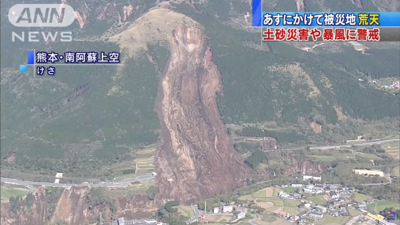
[Main Tweet] Powerful earthquakes continue in Kyushu, including in the vicinty of Minami Aso, home of [the] active Mount Aso volcano in Kumamoto Prefecture.
[Image caption] NHK Special Coverage: In [the] early morning [of[ April 16, Kumamoto Prefecture was violently shaken by two strong Shindo 6 earthquakes. Aftershocks continue, and the Japan Meteorological Bureau cautions citizens to be safe.
Getting the numbers right
Ogawa Hajime, a journalist working with Mainichi News, notes that there were actually three ⤔ not two — earthquakes:
3つの地震。14日と15日は前震、16日が本震だった。この図はそれがよくわかる。 pic.twitter.com/QqMVbKXgWG [6]
— 小川一 (@pinpinkiri) April 15, 2016 [7]
Three earthquakes, and the April 16 quake (the latest one) is apparently the main one. This map shows when and where they happened. [Map, clockwise, from lower right: Mashiki (益城) in center] April 14, 9:26 p.m., Magnitude 6.5 / Shindo 7; April 15, 12:03 a.m., M6.4 / Shindo 6; April 16, 1:25 a.m., M7.3, Shindo 6.
The latest quake occurred at 1:35 a.m. local time on Saturday, April 16. The epicenter was once again located in the city of Kumamoto, but damage was reported throughout the island, notably in the Kumamoto and Oita prefectures.
Devastating effects
The village of Minami Aso, in eastern Kumamoto, at the foot of Mount Aso, Japan's largest active volcano, was hit particularly hard.
The earthquake, combined with heavy rains, caused landslides that washed out roads.
南阿蘇村中心部へのアプローチが寸断。路面は十メートル下に転落している。こうした道路崩落が救助活動を困難にしている。この辺りの地盤は余震で大きく揺れる。かなり危険だ。 pic.twitter.com/r9fG6dbeaz [8]
— 竹内明 Mei Takeuchi (@nygangsta0327) April 16, 2016 [9]
All approaches to the heart of the municipality of Minami Aso are blocked. A crevasse has dropped the road surface by as much as 10 meters. Landslides like this are hindering relief and rescue efforts. Large, violent aftershocks continue. It's dangerous to be here.
The town Uto [10], about 10 kilometers southwest of Kumamoto Prefecture, was also reported to be hard hit by the earthquake.
宇土市役所の庁舎…
災害対策本部なだけに気が気じゃないです…
天草も揺れてます…
熊本市内でも、市民病院が傾いていて避難してるそうです。
まだ余震が続くみたいなので、気をつけてください。#地震 [11]#拡散希望 [12] pic.twitter.com/km1TUYWhWi [13]— ARIA@南極行ってきた。 (@07_good) April 15, 2016 [14]
Uto Municipal Hall [15]: this is supposed to be the disaster management center. Amakusa (also in Kumamoto Prefecture, southwest of Uto) has also been hit by an earthquake. In Kumamoto City apparently casualties are flooding in. Aftershocks are continuing so please take care of yourselves.
Heavy rains over the weekend have also caused massive landslides that have wiped out roads, destroyed train tracks, and made life miserable for evacuees stuck out in the open.
【熊本・南阿蘇村の被災現場は】
山の斜面が広い範囲で崩れ、大量の水が流れだしています。
橋が寸断されている様子も見えています。 pic.twitter.com/tJ7L0guDaJ [16]— NHK生活・防災 (@nhk_seikatsu) April 15, 2016 [17]
[Scenes of Disaster in Minami Aso, Kumamoto] A large section of hillside has collapsed as torrential flooding continues. We can see that a bridge has been washed out.
There are also reports [18] that dams have been weakened, raising fears of collapse and subsequent flooding of low-lying areas.
Many dead, injured and displaced
While the number of casualties may likely rise, 37 people have been reported dead thus far [1], with hundreds more wounded and tens of thousands left homeless. Up to one hundred people [19] were trapped under buildings.
【速報】益城町などで多数の人が『生き埋め』との情報!
熊本の病院では数えきれないほどのケガ人が押し寄せている!
※専門家:今回のM7.1が『本震』の可能性!https://t.co/BUGFDWRAby [20]#熊本地震 [21] pic.twitter.com/iCMr5D7Wy3 [22]— ゆる系速報・ぽん太くん (@JPNG5) April 15, 2016 [23]
In Mashiki Township (east of Kumamoto City) there are reports of dozens of people trapped under toppled buildings. There are large numbers of injured reportedly being treated at Kumamoto hospitals.
Note: according to an expert, this Magnitude 7.1 quake is the actually the main quake (and the April 14 quake was merely a precursor).
Even newer homes could not withstand the force of the tremors, and fire from ruptured gas lines engulfed many communities.
Earthquake damages scores of homes in Kumamoto Prefecture https://t.co/zPVvbFsEz3 [24] pic.twitter.com/YzRn4zWc1c [25]
— YouTube Newswire (@ytnewswire) April 15, 2016 [26]
In the Kyushu region of Japan, damage from spreading in the big earthquake of 3 consecutive days!(日本の九州地方、大地震で被害拡大!) pic.twitter.com/mCSstBVYku [27]
— 藤田桂輔 (@KeisukeFujitajp) April 15, 2016 [28]
Frightening scenes of the earthquake and its aftershocks were captured on television:
Large aftershocks were ongoing, even as local media tried to transmit news about the earthquakes.
<速報>熊本朝日放送の局アナが地震に腰抜かした pic.twitter.com/yNLhUSyOwg [29]
— 岡三マン (@okasanman) April 15, 2016 [30]
Breaking: Kumamoto Asashi Broadcasting announcer scared witless by violence of earthquake.
Examining the earthquakes
Tokyo Metropolitan University researcher Hidenori Watanave [31], who recently helped launch an innovative mapping tool [32] that examined the aftermath of the 2011 Tohoku Tsunami, used another tool — typhoon.mapping.jp [33] — to examine the scale of the earthquakes occurring in northern Kyushu at this time.
地震の震源と規模が緑色の円であらわされています.これほど重なり合っている状態ははじめてみました. https://t.co/Q42hDP7N5C [34] pic.twitter.com/N5J84cZYiP [35]
— Hidenori Watanave (@hwtnv) April 15, 2016 [36]
The intensity of the earthquake epicenters is expressed as colored circles. I haven't seen this sort of overlapping or clustering before. typhoon.mapping.jp [33]
The second of the three quakes, which occurred at 12:03 a.m. local time on Friday, April 15, was regarded to be the “main quake”.
今回の地震が「本震」気象庁の地震津波観測課長が見解 https://t.co/yQont2nhyS [37]
— ハフィントンポスト日本版 (@HuffPostJapan) April 15, 2016 [38]
This earthquake (occurring at April 15, 12:03 a.m.) is the “main quake”, and yesterday's quake (which centered around Mashiki and Kumamoto) was a actually a precursor. The Japan Meteorological Agency has lifted a tsunami warning.
The third quake that occurred early in the morning of April 16 caught everyone off guard. Some experts have noted that there is no possible way to state when a “main” earthquake has occurred.
Robert Geller [39], a seismologist at Tokyo University, said:
「前震」と「本震」は事後に指定する。前もって区別できない。
— Robert Geller (@rjgeller) April 15, 2016 [40]
A “precursor” earthquake and a “main” earthquake can only be determined (well) after the fact. There is no way to predict when a major earthquake will occur (or when earthquakes will stop).
Geller, who posts in both English and Japanese, has been providing a steady stream of tweets that both inform and correct earthquake reporting.
Intensity = scale for shaking at one point.
Magnitude = size of quake (6.5 or so)
Not so large, but under the city https://t.co/4EQqlVFzC4 [41]— Robert Geller (@rjgeller) April 14, 2016 [42]
The maximum intensity (7) and the magnitude (about 6.5) appear similar, but actually these are completely different parameters. @rjgeller [43]
— Robert Geller (@rjgeller) April 14, 2016 [44]
Geller is known to be critical of the accuracy of Japan's system of earthquake prediction. Hiroko Tabuchi, who formerly covered Japan for the New York Times, highlighted Geller's skepticism:
Interesting tweets from Tokyo Uni seismology prof @rjgeller [43] on how Kumamoto earthquake again proves Japan's quake prediction program useless
— Hiroko Tabuchi (@HirokoTabuchi) April 15, 2016 [45]
In the aftermath of the earthquakes, Geller said:
地震予知ができないのに、気象庁に地震予知情報課がある。
理解できないのは僕だけでしょうか?https://t.co/1OTRhzv9u6 [46]— Robert Geller (@rjgeller) April 15, 2016 [47]
Even though there is no way to predict earthquakes, the Japan Meteorological Agency still has a section devoted to “earthquake prediction.” Am I the only guy who doesn't understand why this is?
Residents on edge
For now, many people in Japan are uneasily considering the possibility of whether or not Mount Aso, Japan's largest active volcano [48], located right in the middle of the earthquake zone, will erupt.
【熊本地震】相次ぐ地震と関連か 阿蘇山「小規模噴火」で100M噴煙も https://t.co/AN3QrBCXQN [49] #日刊ゲンダイDIGITAL [50]
— 日刊ゲンダイ (@nikkan_gendai) April 16, 2016 [51]
Kumamoto Earthquake: will earthquakes continue to occur one after another? Mount Aso's small-scale eruption releases cloud of ash 100 meters high.
Earthquake coverage can be followed on Twitter using the hashtags #地震 [52] and #熊本地震 [53].
This article has been updated, with thanks to Peter Durfee [54].