As we indicated previously, the regional hackathon Developing Latin America 2012 (#DAL2012) held a workshop highlighting Open Street Maps. The workshop, which was outfitted with live streaming [es] allowing it to be remotely broadcasted [es], featured MapBox data expert Alex Barth. More information, including a video of the weekend, can be found here [es].
But first, what exactly is web mapping? According to Wikipedia, “web mapping is the process of designing, implementing, generating and delivering maps on the World Wide Web and its product.” The article adds:
“The use of the web as a dissemination medium for maps can be regarded as a major advancement in cartography and opens many new opportunities, such as realtime maps, cheaper dissemination, more frequent and cheaper updates of data and software, personalized map content, distributed data sources and sharing of geographic information. It also implicates many challenges due to technical restrictions (low display resolution and limited bandwidth, in particular with mobile computing devices, many of which are physically small, and use slow wireless Internet connections), copyright[3] and security issues, reliability issues and technical complexity. While the first web maps were primarily static, today's web maps can be fully interactive and integrate multiple media. This means that both web mapping and web cartography also have to deal with interactivity, usability and multimedia issues.”
Which is to say, the backstory of each map you see on the internet likely represents a fair number of challenges but more assuredly a tremendous amount of work.
In order to better understand the process, we talked with MapBox engineer Ian Ward who provided this insight:
While it's worth noting that there are numerous mapping applications, the following specifically highlight those produced by Open Street Maps.
In a post published by Development Seed, Ian describes an initiative in Ayacucho, Peru, which sought to map the city's public transportation routes.
Previously, this transit data only existed in AutoCAD files, accessible to only a handful of people. Now it is publicly available in open formats ready to be used in maps like this and for any other purpose. […]
Looking at just transit data, it’s now possible to assess city traffic, identify where traffic lights are needed, and simply show tourists how to get to the best local restaurants. New information can be cataloged, such as intersections with heavy pedestrian traffic, allowing city planners to better direct changes and new traffic and pedestrian signals.
Note: The information on this map is from 2009, the start of this project.
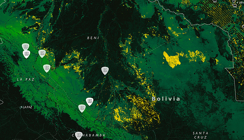
In a guest post written for Development Seed, InfoAmazonía's Juliana Mori explains a similar project in Brazil:
InfoAmazonia now maps deforestation data for the entire Amazon basin dating back to 2004, revealing how forest loss patterns play out in different countries. When O Eco, Knight-ICFJ, and Internews first launched InfoAmazonia ahead of the Rio+20 earlier this year, deforestation data was only available for Brazil. This addition brings deforestation data from all nine Amazonian countries into one map, using data from Terra-i. Now journalists and others can locate deforestation information across the region in diverse political, social, and environmental contexts.
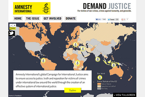
To further solidify the point, Jue Yang, Development Seed team member, recounts a map specifically developed for Amnesty International:
We designed a narrative map for Amnesty International’s new Campaign for Global Justice calling for international support and legal action against perpetrators of war crimes, crimes against humanity and genocide.
With built-in navigation, the map shows a comprehensive picture of Amnesty’s current work around the world and countries’ support of the International Criminal Court – shown through map layers visualizing data on support of action, justice, and reparations. Twitter and a YouTube video are embedded into the map, encouraging viewers to pass the site on and follow Amnesty’s call to demand justice.
The relevance of web mapping is not solely limited to the aforementioned examples. Ian Ward believes the future of mapping will expand to include various fields, not the least of which is journalism, for example.
For those interested in this topic, we recommend visiting OpenStreetMap's wiki page (also available in Spanish [es]). If you are in Peru, click here [es] to find a community near you.
Furthermore, if you are part of any institution with open data you would like included on a map, visit the hackathon's Developing Latin America 2012 [es] page and contact developers and experts in web mapping!
Related posts:
Developing Latin America 2012
What Exactly is a Hackathon? And What is Open Data?
Hackathons in Droves: How is a Hackathon Organized?
Developing Latin America Hackathon Draws Near!
Brazil: Rio de Janeiro Demands Better Sanitation
Perú: Crowdmapping Water Contamination in Peruvian Indigenous Communities


1 comment