In the first post of this series, we saw how various citizen-coordinated initiatives came into play during natural disasters such as Hurricane Katrina or the Indian Ocean Tsunami, to help in the response and recovery and even function as disaster management systems.
In this post, we will examine some more ICT based tools and applications in the arena of early warning systems to help reduce damage to life and property in natural disasters across the globe.
Esther Nakkazi, writes in her Ugandan ScieGirl blog:
Research done with the International Telecommunication Union (ITU) has proven that an investment of [every] $1 in ICTs used for disaster management through monitoring and response could save $14- $22 for rehabilitation after the disaster.
Some of the key challenges in the path of early disaster prediction and warning are that of data collection, analysis and dissemination. Remote sensing and GIS capabilities through seismographic networks, deep ocean sensors, and satellite based systems, are being focused on by governments to meet these challenges and develop effective early warning systems as in the case of the various Tsunami Warning Systems across the globe.
Wilbur K. Ottichilo writes in Agritech Kenya about Africa's use of satellite based technology in the area of disaster warning:
In the last six years, RCMRD (Regional Centre for Mapping of Resources for Development) has been at the forefront of promoting remote sensing and GIS in Africa, collaborating with NASA to establish a satellite-based disaster early warning system known as SERVIR for Africa. SERVIR provides real-time information on many disasters, including droughts. The information is made freely available on the Internet.
Many other organisations and institutions in Africa are now also providing satellite data and information for drought and disaster management, including the InterGovernmental Authority on Development’s Climate Prediction and Application Centre (ICPAC), in East Africa, the Southern African Development Community, and AGRIMET in West Africa.
Chanuka Wattegama writes in an e-primer for the United Nations Development Programme “ICT and disaster management” [pdf]:
The first important steps towards reducing disaster impact are to correctly analyse the potential risk and identify measures that can prevent, mitigate or prepare for emergencies. ICT can play a significant role in highlighting risk areas, vulnerabilities and potentially affected populations by producing geographically referenced analysis through, for example, a geographic information system (GIS). The importance of timely disaster warning in mitigating negative impacts can never be underestimated.
Navigation and mapping tools such as GPS, Google Earth, and Google Maps are therefore increasingly becoming indispensable in designing effective Disaster Management Systems. According to John Hanke, the Director of Google Earth and Maps, these applications proved their mettle during the days of Hurricane Katrina:
Over several long nights, the teams from Google Earth and Google Maps created satellite imagery overlays of the devastation in the affected region, which showed more accurately the scope of the disaster. Soon after, we were told that rescue workers and the U.S. Air Force were using Google Earth to find people who were stranded.
Given the high penetration of mobile phones across the globe, use of mobile alerts through bulk SMS cell broadcasting, to send out early warnings to the communities at risk, is increasingly becoming a mainstay of an effective disaster management system. Growing importance of open-source applications such as FrontlineSMS, RapidSMS is likely in the near future.
Governments of various countries too are now including mobile alerts in their kitty of early public warning systems. For example, the Bangladeshi authorities are currently trialling a text message disaster alert service which will enable them to warn the public (mobile phone subscribers) of impending natural disasters, such as floods and cyclones. SMS based services are also coming in handy for aid organisations in the arena of disaster response and/or mitigation. For example, post-tsunami, the Sri Lankan government used SMS services to inform people of locations from where aid was being distributed.
In her article “Mobile Cell Broadcasting for Commercial Use and Public Warning in the Maldives” Natasha Udu-Gama explains the benefits of cell broadcasting in the context of the disaster-prone Maldives [pdf]:
The use of cell broadcasting for public warning in the Maldives has gained more attention, since the unique characteristics of the country appear to complement this technology. An island nation composed of groups of 26 atolls of about 1,192 islets of which 250 islands are inhabited, it is crucial that a public warning system be able to reach all of the inhabited islands scattered within the Maldives.
In the following video by MobileActive08, Robert Kirkpatrick of inSTEDD.org, Erik Hersman of Ushahidi, and Christopher Fabian of UNICEF discuss the role of mobile media in crisis and disaster relief.
“Can Telecenters become Disaster Early Warning Centers?” asks Sameera Wijerathna, an ICT4D Activist in Sri Lanka, in this post. His answer – both yes and no.
Yes, it can be. Telecentre is a place rich with ICT.
No, it is too much to expect from a Telecentre.
Most of the telecentres are located in rural areas; most of those areas are prone to disasters, natural or man-maid. Telecentres located in those areas but still with ICT facilities telephone, internet, fax, etc. can receive a message from a central disaster early warning centre. So if we have a simple mechanism to disseminate that information, maybe using megaphones we can convert a Telecentre to Early Warning Centre in the village. Even after the disaster occurred, that Telecentre can continue a play a role of coordinating the relief work, impact assessment, finding missing people
Updates on Social Networking sites such as Facebook and Twitter can also act as warning systems. Twitter has already proved its utility in the arena of breaking news, including early information on natural disasters. Yet, there are some concerns regarding the reliability of tweets as a formal early warning system by government authorities.
Mark Prutsalis at Living Prepared Blog in New York expresses his concern over government agencies using Twitter as an emergency notification service.
No government agency should be using Twitter as an emergency notification service. That would be irresponsible… Twitter is not reliable enough for any government agency to use as an “emergency notification service” (or for an individual to use the sole means to be notified). Those government agencies who choose to tweet emergency event information should only be doing so in addition to a formal alert & warning system that they control the infrastructure for – or is under the control of a commercial company who has been contracted to provide such services with a guaranteed service level agreement in place.
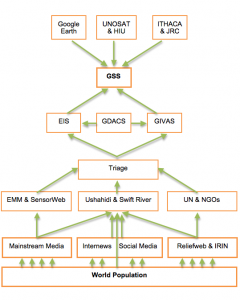
On Conflict Early Warning and Early Response, Patrick Meier discusses an ecosystem based approach to effective early disaster warning and response that will allow for self-organized “P2P capacity building”. Moving on to a global perspective of this very ecosystem, he wonders about the possibilities of connecting the various early warning platforms and information sources available today to form a super-system GSS (Global System of Systems) as depicted below:
Could this indeed be the future path for global early warning systems? Meier offers some food for thought:
What if we connected these various organisms to catalyze a super organism? A Global System of Systems (GSS)? Would the whole—a global system of systems for crisis mapping and early warning—be greater than the sum of its parts?
[…]
Can such a global Info Web be catalyzed? The question hinges on several factors the most important of which are probably awareness and impact. The more these individual organisms know about each other, the better picture they will have of the potential synergies between their efforts and then find incentives to collaborate.


1 comment
I really appreciated your perspective on ICTs in disaster management. The company I work at, Depiction, Inc. (www.depiction.com), makes mapping/simulation software that is used significantly for that purpose, both by government agencies and grassroots volunteers–while it’s a very powerful suite of GIS tools, its built and priced for the everyday person. We believe that by making what was previously the province of skilled GIS technicians available to to the masses, we’re building a part of that disaster management ecosystem.
You can see the post here: http://www.depiction.com/blog/icts-in-disaster-management